|
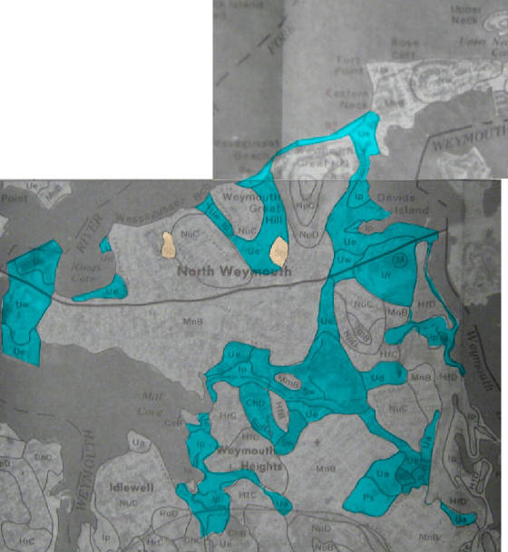
Soil types present in North Weymouth
|
Published
Map Unit Symbol |
Map Unit Name |
Hydric
Soil |
Farmland
Class |
| 610 |
Be |
Beaches |
|
|
| 420B |
CaB |
Canton fine sandy loam, 3 to 8 percent slopes |
No |
Prime |
| 420C |
CaC |
Canton fine sandy loam, 8 to 15 percent slopes |
No |
|
| 420D |
CaD |
Canton fine sandy loam, 15 to 35 percent slopes |
No |
|
| 422B |
CbB |
Canton fine sandy loam, 3 to 8 percent slopes, extremely stony |
No |
|
| 422C |
CbC |
Canton fine sandy loam, 8 to 15 percent slopes, extremely stony |
No |
|
| 422D |
CbD |
Canton fine sandy loam, 15 to 25 percent slopes, extremely stony |
No |
|
| 424B |
CcB |
Canton fine sandy loam, 3 to 8 percent slopes, extremely bouldery |
No |
|
| 424C |
CcC |
Canton fine sandy loam, 8 to 15 percent slopes, extremely bouldery |
No |
|
| 424D |
CcD |
Canton fine sandy loam, 15 to 25 percent slopes, extremely bouldery |
No |
|
| 628C |
CdC |
Canton-Urban land complex, 3 to 15 percent slopes |
No |
|
| 103B |
ChB |
Charlton-Hollis-Rock outcrop complex, 3 to 8 percent slopes |
No |
|
| 103C |
ChC |
Charlton-Hollis-Rock outcrop complex, 8 to 15 percent slopes |
No |
|
| 103D |
ChD |
Charlton-Hollis-Rock outcrop complex, 15 to 25 percent slopes |
No |
|
| 630C |
CuC |
Charlton-Hollis-Urban land complex, 3 to 15 percent slopes |
No |
|
| 256A |
DeA |
Deerfield loamy sand, 0 to 3 percent slopes |
No |
Prime |
| 256B |
DeB |
Deerfield loamy sand, 3 to 8 percent slopes |
No |
Prime |
| 52 |
Fm |
Freetown muck |
Yes |
|
| 53 |
Fp |
Freetown muck, ponded |
Yes |
|
| 251A |
HaA |
Haven silt loam, 0 to 3 percent slopes |
No |
Prime |
| 251B |
HaB |
Haven silt loam, 3 to 8 percent slopes |
No |
Prime |
| 253B |
HfB |
Hinckley sandy loam, 3 to 8 percent slopes |
No |
|
| 253C |
HfC |
Hinckley sandy loam, 8 to 15 percent slopes |
No |
|
| 253D |
HfD |
Hinckley loamy sand, 15 to 35 percent slopes |
No |
|
| 104C |
HrC |
Hollis-Rock outcrop-Charlton complex, 3 to 15 percent slopes |
No |
|
| 104D |
HrD |
Hollis-Rock outcrop-Charlton complex, 15 to 35 percent slopes |
No |
|
| 65 |
Ip |
Ipswich mucky peat |
Yes |
|
| 254A |
MmA |
Merrimac fine sandy loam, 0 to 3 percent slopes |
No |
Prime |
| 254B |
MmB |
Merrimac fine sandy loam, 3 to 8 percent slopes |
No |
Prime |
| 254C |
MmC |
Merrimac fine sandy loam, 8 to 15 percent slopes |
No |
|
| 626B |
MnB |
Merrimac-Urban land complex, 0 to 8 percent slopes |
No |
|
| 300B |
MoB |
Montauk fine sandy loam, 3 to 8 percent slopes |
No |
Prime |
| 300C |
MoC |
Montauk fine sandy loam, 8 to 15 percent slopes |
No |
|
| 302B |
MsB |
Montauk fine sandy loam, 3 to 8 percent slopes, extremely stony |
No |
|
| 302C |
MsC |
Montauk fine sandy loam, 8 to 15 percent slopes, extremely stony |
No |
|
| 325B |
NpB |
Newport silt loam, 3 to 8 percent slopes |
No |
Prime |
| 325C |
NpC |
Newport silt loam, 8 to 15 percent slopes |
No |
|
| 325D |
NpD |
Newport silt loam, 15 to 25 percent slopes |
No |
|
| 627C |
NuC |
Newport-Urban land complex, 3 to 15 percent slopes |
No |
|
| 305B |
PaB |
Paxton fine sandy loam, 3 to 8 percent slopes |
No |
Prime |
| 305C |
PaC |
Paxton fine sandy loam, 8 to 15 percent slopes |
No |
|
| 305D |
PaD |
Paxton fine sandy loam, 15 to 25 percent slopes |
No |
|
| 307B |
PbB |
Paxton fine sandy loam, 3 to 8 percent slopes, extremely stony |
No |
|
| 307C |
PbC |
Paxton fine sandy loam, 8 to 15 percent slopes, extremely stony |
No |
|
| 307D |
PbD |
Paxton fine sandy loam, 15 to 25 percent slopes, extremely stony |
No |
|
| 601 |
Pr |
Pits, quarry |
No |
|
| 600 |
Ps |
Pits, sand and gravel |
No |
|
| 345B |
PtB |
Pittstown silt loam, 2 to 8 percent slopes |
No |
Prime |
| 30 |
Ra |
Raynham silt loam |
Yes |
|
| 70A |
RdA |
Ridgebury fine sandy loam, 0 to 5 percent slopes |
Yes |
|
| 71B |
RgB |
Ridgebury fine sandy loam, 2 to 8 percent slopes, extremely stony |
Yes |
|
| 04 |
Rm |
Rippowam silt loam |
Yes |
|
| 105D |
RoD |
Rock outcrop-Hollis complex, 3 to 25 percent slopes |
No |
|
| 05 |
Sa |
Saco silt loam |
Yes |
|
| 10 |
Sb |
Scarboro and Birdsall soils |
Yes |
|
| 223B |
ScB |
Scio very fine sandy loam, 2 to 5 percent slopes |
No |
Prime |
| 315B |
SeB |
Scituate fine sandy loam, 3 to 8 percent slopes |
No |
Prime |
| 317B |
StB |
Scituate fine sandy loam, 3 to 8 percent slopes, extremely stony |
No |
|
| 260B |
SuB |
Sudbury fine sandy loam, 2 to 8 percent slopes |
No |
Prime |
| 51 |
Sw |
Swansea muck |
Yes |
|
| 653 |
Ua |
Udorthents, sandy |
No |
|
| 654 |
Ud |
Udorthents, loamy |
No |
|
| 655 |
Ue |
Udorthents, wet substratum |
No |
|
| 652 |
Uf |
Udorthents, refuse substratum |
No |
|
| 602 |
Ur |
Urbanland, 0 to 15 percent slopes |
No |
|
| 603 |
Uw |
Urbanland, wet substratum, 0 to 3 percent slopes |
No |
|
| 604 |
UxA |
Urban land-Boxford complex, 0 to 3 percent slopes |
No |
|
| 31A |
WaA |
Walpole sandy loam, 0 to 5 percent slopes |
Yes |
|
| 73A |
WhA |
Whitman fine sandy loam, 0 to 5 percent slopes, extremely stony |
Yes |
|
| 255A |
WnA |
Windsor loamy sand, 0 to 3 percent slopes |
No |
|
| 255B |
WnB |
Windsor loamy sand, 3 to 8 percent slopes |
No |
|
| 255C |
WnC |
Windsor loamy sand, 8 to 15 percent slopes |
No |
|
| 310A |
WrA |
Woodbridge fine sandy loam, 0 to 3 percent slopes |
No |
Prime |
| 310B |
WrB |
Woodbridge fine sandy loam, 3 to 8 percent slopes |
No |
Prime |
| 312B |
WsB |
Woodbridge fine sandy loam, 3 to 8 percent slopes, extremely stony |
No |
|
| 623C |
WuC |
Woodbridge-Urban land complex, 3 to 15 percent slopes |
No |
|