|
Determing the probable or possible location of Weston's 1622 plantation
at Wessagussett depends on three sources: primary documentation, cartographic, local history, and of these three the first
should be given principle emphasis. Clues in the narrative of Phineas Pratt, an actual occupant of the plantation and chronicler
of the events of the spring of 1623, provide good general information and important topographic features located around the
plantation. Other chroniclers were Edward Winslow and William Bradford from the Plymouth plantation. Neither Winslow nor Bradford
were likely to have been present at the attack on Wessagussett and both appear to have relied on descriptions of the events
for their chronicles, with the former's being a more detailed account than the latter's.
Cartographic evidence is limited to a
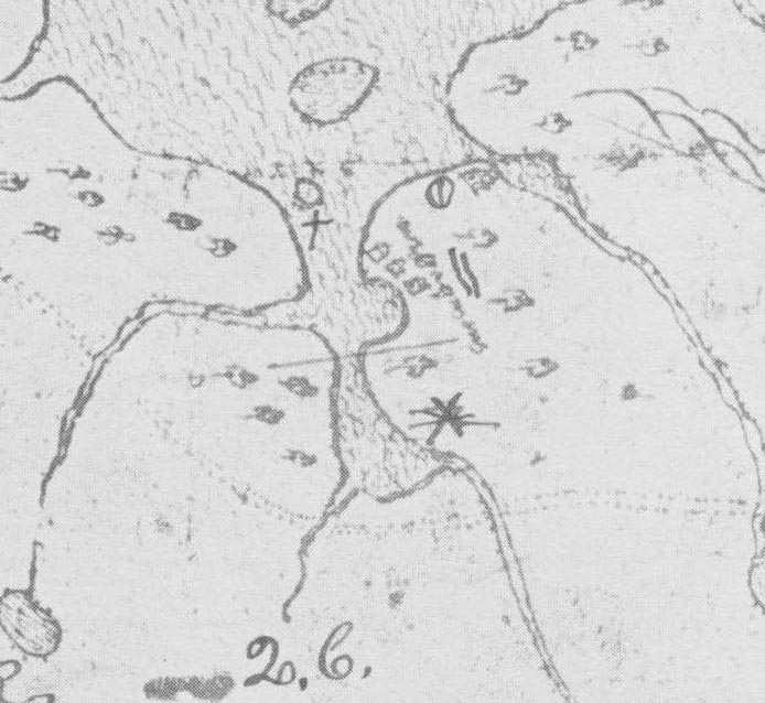
map rendered in 1633 showing the settlement at Wessagussett (see below).
| Winthrop 1630s Map of Wessagussett |
|
On this map, three structures are shown on the western edge of the penninsula
and a fourth structure is shown to the east of the first three. The question is: What does this map show? First off, the map
is not an exact topographic rendering of the area and likely shows generally where settlement was at the time of its rendering
and not where the 1622 settlement was located. In 1633 William Wood recorded that “This as yet is but a small village; yet it is very pleasent and healthful, very
good ground, and is well timbered, and hath good store of hay ground. It hath a very spacious harbour for shipping before
the town, the salt water being navigable for boats and pinnaces two leagues. Here the inhabitants have good store of fish
of all sorts, and swine, having acorns and clams at the time of the year. Here likewise is an alewife river.” (wood
xx). Four structures may be representative of this small village. It is also not possible to exactly locate where the structure
are in relation to the topography of the neck. While settlement was attempted in 1622 and 1623, no permanent settlement was
established until the 1630s following the arrival of Winthrop's fleet and the settler's subsequent spread into the hinterland
around Boston. It is more likely that the 1633 Winthrop map shows where contemporary settlement was as opposed to where settlement
from a decade prior was located. The map shows settlement on the eastern side of a bay, harbor or inlet in the Fore River,
most likely in th area of Mill Cove, where 1630 settlement is known to have occurred. The structure shown at the mouth of
the Back River looks different from the three structures to the west and may represent a 1633 fort, church, or possibly, the
location of the 1622 fort, the structure definitely does not appear to be another house though.
The site of the Wessagussett
Plantation was reoccupied in the middle of September 1623 by Sir Fernando Gorges Company, which was led by his son Robert
Gorges. Like Weston's men, they hoped to prosper through through trading, but unlike Weston's colony, Gorges arrived aboard
the ships Ketherine and the Prophet Daniel with 120 settlers consisting of men and their families. The colonists
fared no better than Weston, with the exception of having trouble with the local Natives, and the Plantation was abandoned
the following year with some settlers returning to England with Gorges, some going to Virginia, one moving to Plymouth and
eventually back to England, and “his (Gorges) servants and certain other undertakers and tenants” whom Gorges
“left his plantation in charge of”.
Gorges died and his brother
John conveyed part of his New World holding to John Oldham and wrote to William Blackstone and William Jefferies, who were
recorded as living in Boston bay, to put that conveyance into effect (Hazard Historical collection v 1 391). Wessagusset was
recorded as being also called “Jefferies and Burslem's plantation”after two of the settlers who Gorges left behind.
After the assault on Merrymount and Thomas Morton in 1628, the settlers at Plymouth assesed the Jefferies and Burslem plantation
a rate for expedition against Morton (Bradford). Added to these two settlers at Wessagussett was a man named Ludden. Cook's
History of Norfolk County states that “of the 123 landowners mentioned by Mr. Nash, only seventeen are recognized as
members of the Hull company which came over in 1635. John Bursley, William Jeffries and a man named Ludden are recognized
as members of the Gorges company and had no doubt maintained their residence there from the year 1623.”
William Jefferies first
appears in association with Wessagussett in 1628 when William Bradford's history states that he and Mr. Burslem (Bursley)were
assessed two pounds to the fund to return Thomas Morton to England after the disollution of his settlement at Merrymount.
Jefferies was described as a Gentlemanin 1629 when he was noted as one of those authorized to give possession of a grant of
land to John Oldham and Richard Vines. By the early 1640s Jefferies had moved to Newport, Rhode Island.
Research indicates at Ludden was likely James
Ludden, who may have been the man referred to as Laddon or Ludham in the records of Massachsuetts bay ( Geneal. Reg. IX. 171)
as being the man who guided Governor Winthrop to Wessagussett from Boston while on his way to Plymouth. James Ludden is believed
to have been born in 1611 and died in 1692.
The will of Captain John
Holbrook (July 2, 1699) of Weymouth, gives some indication of 1) where settlement was located in the 1660s; 2) two of the
local place names; 3) where at least some James Ludden's land was located. Holbrook had a house in Boston, one in Scituate
and one in Weymouth. His Weymouth house and a parcel of saltmarsh were located at “Kingman's Neck” and 40 acres
at “Physical Spring”. It is unknown where exactly these areas where, but they are believed to lie in “Old
Spain” in Weymouth. He left to his grandsons Benjamin Ludden, John Ludden and Joseph
Ludden 10 pounds each and left to his other grandson James Ludden a meadow on the Eastern Neck which was his grandfather
James Ludden's. The eastern neck is east of Great Hill along where River Street now runs. Kingman's Neck is likely the place
where Henry Kingman, who arrived with the Reverand Hull settlers in 1636, kept the ferry that he was authorized to keep in
1636 (Massachusetts Bay Colony Records, 1: 165, 225)http://ancestor.homestead.com/files/Henry_Kingman.htm). Kingman's ferry is believed to have operated between Weymouth and Quincy
where the Fore River Bridge is today. King's Cove may refer to the land and cove owned by Kingman, placing Kingman's house
where the present electric plant is today.
|